 Map at Mass Archives
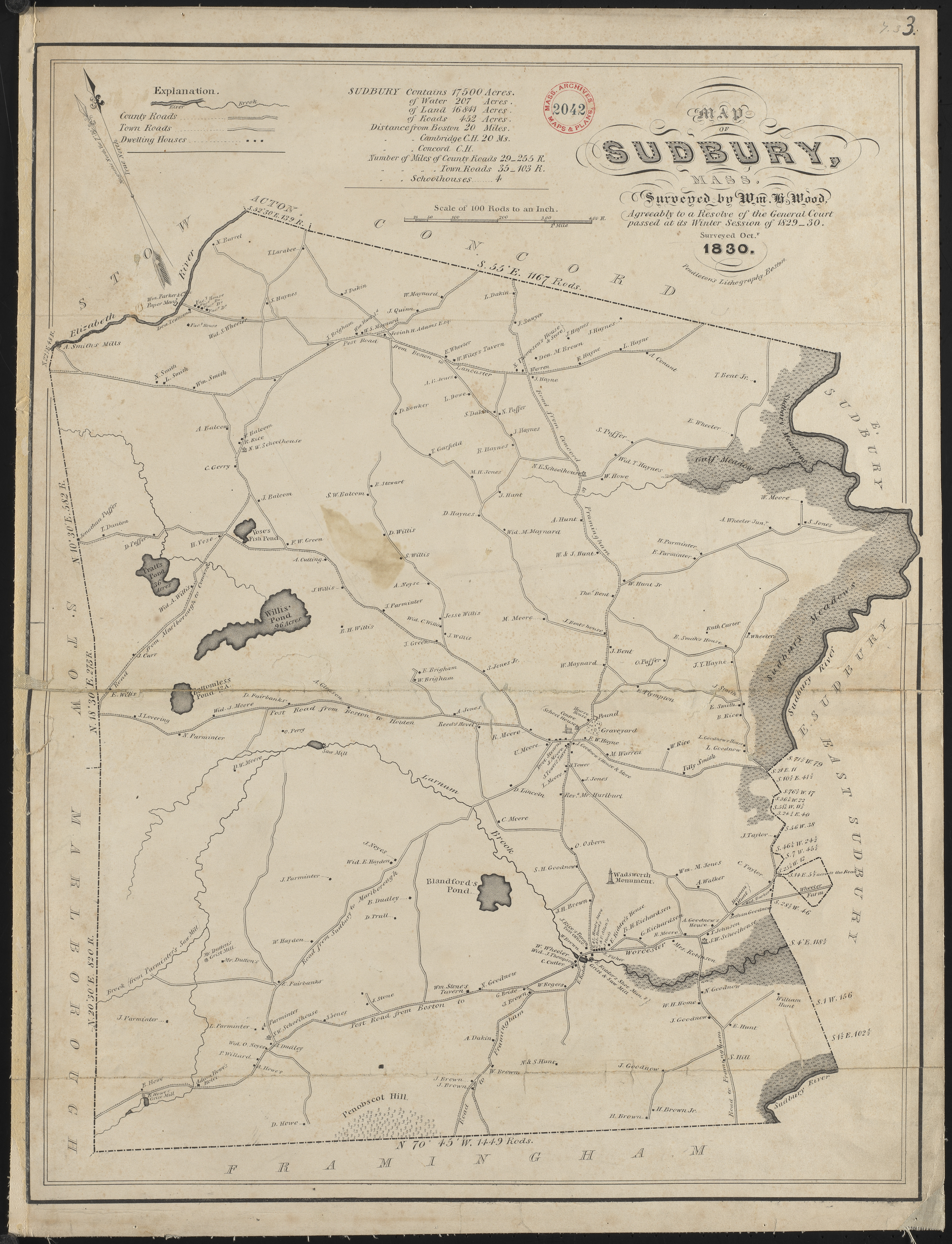
Page 7
Title: Map of Sudbury, 1830
Author: Wm. Wood
Reproduction courtesy: The Sudbury Historical Society, Inc.

On Dec 21, 2011, at 6:50 AM, Michael Buehler wrote:
--I don't have much to add about other maps of Sudbury, but:
If you haven't already seen it, the 1830 printed Wood is based on a manuscript that is almost certainly held at the Mass. State Archives. It is likely that there are also 1 or more copies of the manuscript somewhere in town. For more information about the context of this map, see the article Early Plans of Massachusetts Towns on page 2 of one of my newsletters:
His tombstone in the Hudson Cemetery:
- Col. William H Wood, died Aug 4 1864, aged 62 yrs
- Caroline, his wife, died May 24 1879, aged 77 yrs
Mass Archive entry for William H Wood Showing:
Plan of West Boylston made by William H. Wood, dated September 1830.
Plan of Sudbury made by William H. Wood, dated October 1830.
Plan of Marlborough made by William H.
In 1830 the legislature mandated that every town conduct a survey and submit a map to the Secretary of State. These were to be quite large scale (1 inch to 100 rods, or 1:19,800); indicate the length and bearing of town boundaries; delineate roads and waterways; and show the locations of meeting houses, schools, mills, mines etc. Hundreds of maps were duly produced and submitted, and some years later they were compiled by Simeon Borden into the Topographical Map of Massachusetts (1844), page 33.
These surveys were conducted by the centuries-old metes-and-bounds method. Using a compass for taking bearings and a rod (16.5 feet) or chain (66 feet) for measuring distances, a surveying team would work its way in a continuous path along the boundary to be measured, recording bearings and distances between objects designated as boundary markers. This arrangement required a minimum of three men, one to handle the compass and two to manage the distance measurements.
So long as no one moved the markers, metes-and- bounds surveys worked well enough for surveying the bounds of small properties. Over larger distances such as the territory of a New England town, however, they tended to produce flawed results, due to the limitations of the instruments, the methods, and the surveyors themselves. So inaccurate were some of the Massachusetts town surveys of the 1830s that in 1844 Borden wrote to Walling “in one instance I placed the maps of two towns upon the space required to be filled by them, and found room enough left to place the map of Boston between them.”
At a legal meeting of the inhabitants of the Town of Sudbury held o nMonday the sixth day of March in the year of our Lord one thousand eight hundred and thirty seven the articles in the preceeding warrant were taken up and acted upon in the following manner.
Then voted to accept of the following Report.
Agreeable to a vote of the town passed Nov. 11th 1833 the Subscriber purchased of Mr. Wood of Marlborough 150 Maps of the town of Sudbury for 68 Dollars:
41 were sold at cost: 36 were sold by Mr. Wood at 12 cts. above cost, which 12 Cents were received by the subscriber to be refunded to the purchaser:
which has been refunded to all but six who have not as yet asked for it:
And to pay for the remaining 173 Maps he received a town order to the amount of $48.44.
Agreeable to a vote of the town passed March 2nd 1835 he sold at auction on
| Monday April 6th 16 Maps at 17 cts | $ 2.72 |
| 1 at 16 cts | 0.16 |
| 1 at 15 cts | 0.15 |
| 1 at 14 cts | 0.14 |
| 6 at 13 cts | 0.78 |
| 3 at 12.5 cts | 0.37 |
| 5 at 12 cts | 0.60 |
| 1 at 11 cts | 0.11 |
| 51 at 10 cts | 5.10 |
| Sold by order of the Selectmen the old Bell Rope | 0.33 |
| $10.46 | |
| Sold since at private sale 11 Maps at 10 cts | 1.10 |
| The remaining 75 Maps were advertised & sold )
at the same time the Books of the Sudbury ) Social Library were sold and for which the ) Auctioneer paid two Dollars 20/100 ) | 2.20 |
| $13.76 | |
| Paid auction duties on Sale March 2nd 1835 $0.10 | |
| Paid for Book forTownRecords ---- 3.00 | |
| Paid Cash to the Town Treasurer as pr. Recpt. 10.66 | $13.76 |
YON 2014.11.15 (2015.05.05 locator)